

1.1 Geography and Society
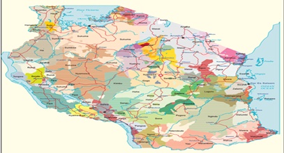
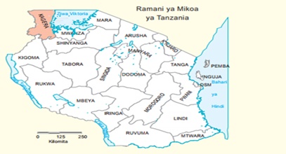
The people whose language is the subject of this study inhabit the district of Karagwe, in the northwestern corner of Tanzania. The district covers an area of 2,700 square miles, stretching roughly from 30°30’ to 31°30’E, and from 1° to 2°S. This constitutes the core of the old Karagwe kingdom, but it is said that the kingdom used to stretch further south and east before German colonialists gave part of the territory to Karagwe’s neighbours whose kings collaborated with the invaders at the end of the 19th century (Katoke 1970, 1975; Cory n.d.; Webster 1979). The current territory is almost completely demarcated by natural boundaries. The Kagera River constitutes the western boundary with Rwanda, the northern boundary with Uganda, and the northeastern boundary with the district of Bukoba within Tanzania. A tributary of the Kagera, River Mwisa, and Lake Burigi and the adjoining marshland, form the eastern boundary with Bukoba and Muleba districts. The southern boundary with Ngara district consists of a straight line from the southern tip of Lake Burigi just south of the 2nd parallel. The name of the territory, Karágwe, derives from the verb kuraga – “bequeath”, “bid farewell”, and here may be rendered “let you be bequeathed (something)” or “may someone bequeath something to you”. The pretender to the old throne, Mr. Cosmas Rumanyika, suggests that there used to be a village to with that name in the southern part of the kingdom.